Search
 
 
  ISRO
WWW


Launch Date
12.07.2010
 
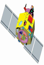
CARTOSAT - 2B is the seventeenth satellite in the Indian Remote Sensing Satellite series (IRS). CARTOSAT-2B carries a Panchromatic camera (PAN) similar to those of its predecessors - CARTOSAT-2 and 2A. It is capable of imaging a swath (geographical strip) of 9.6 km with a resolution of better than 1 metre. The scene specific spot imagery sent by CARTOSAT-2B's PAN will be useful for cartographic and a host of other applications. The highly agile CARTOSAT-2B is steerable up to ± 26o along as well as across track to obtain stereoscopic imagery and achieve a four to five day revisit capability.
Mission Remote Sensing
Weight 694 kg (Mass at lift off)
Onboard Orbit 930 Watts
Stabilization 3 – axis body stabilised based on inputs from star sensors and gyros using Reaction wheels, Magnetic Torquers and Hydrazine Thrusters
Payloads Panchromatic Camera
Launch date July 12, 2010
Launch site SHAR Centre Sriharikota India
Launch vehicle PSLV- C15
Orbit 630 kms, Polar Sun Synchronous
Inclination 97.71º

  Brochure            Photo Gallery
Home  |  About Us  |  ISRO Centers   |  Launch Vehicles  |  Satellites  |  Ground Facilities  |  Our Chairman
Sitemap  |  FAQ   |  Feedback  |  Terms of Use  |  Privacy Policy  |  Contact Us  |  Disclaimer
Copyright 2008 ISRO, All Rights Reserved.
 
Best viewed with a resolution of 1024x768 with Internet Explorer 7.0